Portage County focuses on conserving land
February 5, 2013
A recently released study, entitled “Common Ground,” commissioned by environmentalist groups, park districts and county governments recommends that counties in northeast Ohio need to conserve more land — but not Portage County.
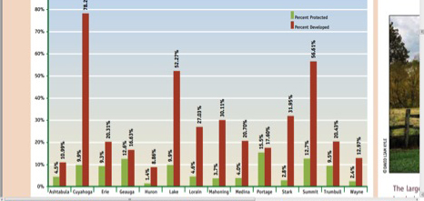
Of the 14 counties and more than 3,000 acres surveyed and analyzed, Portage County protects more land than any county in northeast Ohio. While the creators of the study recommend counties protect between 10 and 15 percent of land, Portage County is conserving 15.5 percent.
The final report was co-written by Ken Wood of the Western Reserve Land Conservancy, which is one of the agencies that commissioned the study. He said the Portage County Park District has found creative ways to protect animal habitats, wetlands and farmland.
“The park district is active,” Wood said. “It does a great job within its means to protect land. They’ve done it without the benefit of a levy. They work very diligently.”
Conserving land means entering an agreement with a land trust — such as the Western Reserve Land Conservancy — or county government to ensure that a piece of land is not industrialized, domesticated or developed.
The deal is known as a conservation easement. The agreement protects land even if the original owner sells it to someone else. Once a piece of land is protected, either an environmental agency or park district is required to inspect the land once a year to ensure it is still in prime condition.
Christine Craycroft, executive director of the Portage Park District, said, while a lot of the conserved land in the county is protected by concerned citizens, the park district has also chipped in to help preserve areas as well.
“It’s a big part of our mission to conserve our natural and cultural heritage,” Craycroft said. “The county has been supporting the park district for many years.”
The Portage Park District has managed to protect land throughout the county, despite never passing a levy in its 20-year existence. Craycroft said the district’s budget has been shrinking over the last five years, and has hit an all-time low in 2013.
Craycroft said she believes people in Portage County care about the environment and natural resources in the county, but they may have encountered some bad luck in the district’s five attempts to pass a levy for additional funding. The last attempt was in 2008.
“Some of it is timing, with the economy and all that,” Craycroft said. “But when you look geographically, we’ve got a lot of tremendous resources here with the wetlands, the lakes and the streams. We have a lot of potential out there to do a lot more conservation.”
Even though the park district hasn’t passed a levy, Craycroft said most people choose to protect their land because they care about the environment. She also mentioned there is a financial incentive as well.
Landowners who want to protect their land must first have it appraised which can cost hundreds of dollars depending on the size of the property. However, if the landowner is given a conservation easement, they can receive a tax credit for the cost of the appraisal.
While Portage County is protecting the highest percentage of land in northeast Ohio, the county with the least amount of conserved land is Wayne County with only 1.4 percent of its land protected from development.
Wood said park districts and environmentalists such as the Western Reserve Land Conservancy would love to see northeast Ohio protect more land. However, he said the agencies need to make sure they scrutinize which land to protect.
“I think most of the partners that we work with try to operate strategically, meaning that we try to preserve the best of the best,” Wood said. “That’s sort of a common sense approach. Obviously, if you’re going to develop — make it so it’s going to make sense for everyone — not over a wildlife area, on prime soils or on wetlands.”
Grant Engle is a city reporter for the Daily Kent Stater.
Here’s a screen shot of a table within the report. It shows how much land in the counties is developed compared to how much land is conserved. Design might be able to do something creative with a county map: