


CNN —
Hurricane Lee will take a swipe at parts of coastal New England and Atlantic Canada starting Friday with heavy rain and strong winds that could lead to localized flooding and knock out power across communities.
Lee will continue to track north and weaken through Friday, and its center will be hundreds of miles off the US East Coast. But its massive size – with strong winds extending far from the center of the storm – means gusty winds, locally heavy rain and high surf will push into New England.
Tropical storm conditions – winds of at least 39 mph – are expected to start in southern New England on Friday afternoon, the National Hurricane Center said. The storm’s strongest winds are expected to be largely confined to coastal areas, but gusty winds in inland areas cannot be ruled out, and power outages are possible with trees at risk of coming down in already saturated soil.
Isolated flooding is possible as Lee drenches parts of New England with several inches of rain Friday night into Saturday.
Beach and coast conditions will continue to deteriorate as Lee tracks north on Friday. Dangerous rip currents and surf were ongoing along much of the East Coast, the hurricane center said. Coastal flooding is possible at high tide as the storm’s winds push water toward the shore.
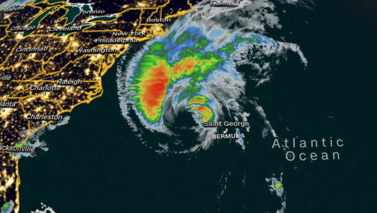
The center of Lee, a Category 1 hurricane, was about 460 miles south-southeast of Nantucket, Massachusetts as of early Friday, carrying maximum sustained winds of 85 mph, the hurricane center said at 8 a.m. ET. Its hurricane-force winds extended up to 105 miles from its center and tropical storm-force winds stretched for up to 320 miles.
Lee whipped strong winds and tropical storm conditions in Bermuda throughout Thursday as it passed west of the island, triggering power outages. Those weather conditions are expected to continue through Friday morning, and an islandwide tropical storm warning remains in effect.
Meanwhile in the US, a combination of hurricane and tropical storm alerts are in effect for many New England coastal communities in anticipation of Lee’s potential impacts Friday and through the weekend.
Tropical storm warnings extend from the Massachusetts coast through Maine and into portions of Canada’s New Brunswick and Nova Scotia provinces. Hurricane watches are in effect for the northernmost coast of Maine, far southwest New Brunswick and western Nova Scotia.
Maine Gov. Janet Mills declared a state of emergency Thursday as Lee approached, requesting federal aid in preparation for the storm.
Provincial and wildlife parks in Nova Scotia will close Friday as Lee inches closer to the area.
“Safety is our priority as we prepare for storm conditions forecast for the weekend,” said Tory Rushton, provincial minister of natural resources and renewables. “We are closing our parks for the storm and will reopen when it is safe.”
Lee is expected to dump its heaviest rain load over Maine on Saturday. Neighboring states including New Hampshire, Massachusetts and Rhode Island could also see rainfall from Lee.
Over the weekend, communities from Rhode Island to northern Maine may see up to an inch of rain. Areas from the Massachusetts Cape to central Maine may receive 1 to 2 inches of rain. Recurrent downpours could boost rainfall totals in eastern Maine to 2 to 4 inches with localized amounts up to 6 inches.

