A historic three-day storm will bring snow, ice and extreme cold across the US
February 22, 2023
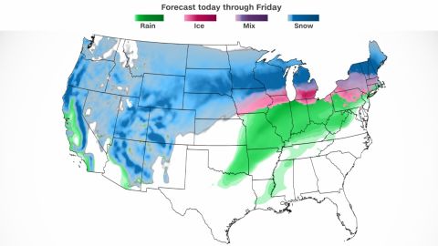
CNN– A powerful, coast-to-coast storm is bringing heavy snow, high winds and ice Wednesday, putting parts of more than two dozen states under winter weather alerts as travel conditions begin to deteriorate in some areas.
More than 65 million people across 29 states, from as far west as California to Minnesota through Maine, are under winter weather alerts that include warnings of severe icing, extreme cold and sleet that are likely to make travel dangerous and knock out power to some.
The Upper Midwest is expected to bear the brunt of the storm in terms of snowfall, with the Minneapolis, Minnesota, area likely getting more than 20 inches Wednesday and more than 2 feet over the multiday storm – potentially the most in 30 years.
The Twin Cities reported 3 to 5 inches of snow Wednesday morning, and a second round of snow and high winds is expected at night into Thursday morning, making for life-threatening travel conditions, the National Weather Service said.
But it’s more than just snow. An ice storm warning is in place across a stretch from Iowa to Michigan and significant icing is possible for the mid-Atlantic by late Wednesday; a severe weather threat and high winds are possible from Oklahoma to Missouri; and flooding is likely from heavy rain in parts of Illinois, Indiana and Ohio.
More than 5 million people are under ice storm warnings across northeastern Iowa, southern Wisconsin, northwestern Illinois and southern Michigan. And more than 2 million are under blizzard warnings across parts of Wyoming, Minnesota, Wisconsin and the Dakotas.
Meanwhile, the Southeast could see record heat for February, with temperatures in the 70s and 80s common across the region – a stark contrast to the frigid conditions in the north.
Out west, strong winds from the powerful storm have already torn down power lines and knocked out power to more than 140,000 homes and businesses in California, where the reported outages occurred in the northern counties of the state including San Mateo, Santa Clara and Santa Cruz, according to the tracking site Poweroutage.us.
California is still bracing for several feet of snow expected in the mountains with a few inches possible in lower elevations, the National Weather Service in Los Angeles said. The unseasonable weather for the state comes nearly two months after rounds of deadly flooding battered many areas.
“Now is the time to prepare for a COLD AND DANGEROUS winter storm expected for much of the week,” the weather service in Los Angeles said. “Gusty and potentially damaging winds are also expected.”
More than 1,000 flights scheduled for Wednesday within the US have been canceled, according to the tracking site FlightAware, mostly in Minneapolis, Denver and Detroit.
Minneapolis facing up to two feet of snow
For Minneapolis, the “historic” three-day storm “will bring widespread accumulating snow, with blowing and drifting snow mainly Wednesday through Thursday,” the National Weather Service in the Twin Cities said.
The worst impacts over the Twin Cities region – which generally includes the cities of Minneapolis, St. Paul and their surrounding suburbs – are expected to begin late Wednesday into Thursday. Heavy snow is expected to blanket the grounds fairly quickly, and be accompanied by gusty winds.
The weather service said to expect sustained winds of 20 to 30 mph with gusts up to 40 mph that will lead to blizzard conditions Wednesday afternoon. A second round of snow overnight will produce another 9 to 12 inches, with some areas getting up to 15 inches, the service said.
Gov. Tim Walz directed the state’s National Guard, the transportation department and the state patrol to be prepared to respond storm impacts, he said on Twitter.
“We’re working to ensure we’re ready – and Minnesotans have a part to play, too. Plan ahead, drive safe, and limit travel,” Walz wrote.
Storm’s path Wednesday
Parts of the Upper Midwest could see snow fall at a rate of 1 to 2 inches per hour, combined with wind gusts of 40 to 50 mph, the National Weather Service said. That unrelenting double whammy is set to create whiteout conditions due to falling and blowing snow.
Those expected conditions have put more than two million people are under blizzard warnings across parts of Wyoming, Minnesota, Wisconsin and the Dakotas.
- Minneapolis: The city could pick up between 15 and 25 inches snow by Thursday. That would be in addition to the 1 to 3 inches that have already fallen there.
- Sioux Falls, South Dakota: In addition to the up to 4 inches of snow the state has already seen, snowfall up to 16 inches and winds of 45 mph are also expected.
- Cheyenne, Wyoming: Heavy snowfall up to 1 foot expected in addition to high winds that could feel as cold as 35 below zero.
- Potentially dangerous icing: Milwaukee in Wisconsin and Detroit and Ann Arbor in Michigan are likely to experience icing beginning Wednesday.
- Severe thunderstorms: Damaging winds and rain are expected Wednesday morning through the afternoon in parts of Oklahoma into western Arkansas, across Missouri and western Illinois, according to the National Weather Service.
Wednesday’s expected conditions have spurred states to take safety measures.
South Dakota’s governor announced Tuesday the closures of state government executive branch offices Wednesday in more than half of the state’s 66 counties, with plans for employees to work remotely. Additionally, Interstates 29 and 90 partially closed Tuesday night to prepare for the expected snow.
Meanwhile in Wyoming, several institutions decided to shutter their doors Wednesday.
Eastern Wyoming College announced the closure of its main campus. The Natrona County school district in Casper will conduct a virtual learning day Wednesday due to hazardous weather and road conditions throughout the area, the district said.
The Food Bank of Wyoming, which says it serves all 23 counties across the state, planned to close Wednesday, it said in a tweet.
CNN’s Robert Shackelford, Andy Rose and Michelle Watson contributed to this report.