Snowfall tops 6.5 feet and rainfall tops 5 inches across southern California
February 26, 2023
CNN — A winter storm dumped massive amounts of precipitation across southern California this weekend, including more than 6.5 feet of snow to Mountain High and more than 5 inches of rain to Cucamonga Canyon.
The hefty snowfall totals included 5 feet to Snow Valley, 57 inches to Bear Mountain Snow Summit, 50 to 55 inches to Wrightwood Acorn Canyon, 45 inches to Green Valley Lake, 38 inches to Mount Baldy, and 36 inches to Lake Arrowhead, according to the National Weather Service in San Diego.
In addition, heavy rainfall brought several inches of rain to the area, including more than 4 inches in Holy Jim Canyon, Lower Silverado Canyon and Henshaw Dam; more than three inches in La Jolla Amago, Costa Mesa, Mount Woodson and Carlsbad Airport; and more than two inches to John Wayne Airport, Escondido, San Bernardino and Temecula, according to the service’s 5-day rainfall reports.
The precipitation came as a rare blizzard warning was in effect for parts of southern California and the Los Angeles region, spawning unfamiliar wintry conditions at higher elevations.
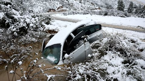
The storm made for dangerous travel conditions in some areas. In Los Padres National Forest, State Route 33 was closed due to rock slides and erosion from this and previous storms, according to video from the California Department of Transportation.
Lynda Sandoval and her husband, who live in Frazier Park, about 65 miles northwest of LA, have been unable to leave their home since Friday, Sandoval told CNN. Heavy snow created dangerous driving conditions in the area and officials have closed sections of Interstate 5.
She told CNN she prepared for the snowstorm and has enough food to last her a few days but is shocked by how much snow has fallen in the area.
“I never have seen this much snow living up here. Neighbors that have been here longer than us said the last snow related to this was back in 2011 but not this severe,” Sandoval said. “It took over 4 hours to get our truck out yesterday and all our neighbors are shoveling snow whenever there is a break. The community up here is amazing with neighbors helping neighbors during this time. They’re sharing groceries and shoveling snow in driveways.”
The same storm system is moving east and is expected to produce a significant damaging wind event across the central US on Sunday. More than 20 million people are under the threat of severe storms Sunday from western Texas to Illinois, including Oklahoma City, Tulsa, Kansas City, Fort Worth, and St. Louis.
Meanwhile, a new winter storm is set to bring more rain and snow to the western US, starting with the Pacific Northwest on Sunday.
More than a foot of snow is possible with the system across the Sierras and Cascades. A second system will be right on the first’s heels, pushing inland across the Pacific Northwest tonight bringing even more snow.
An additional 1 to 2 feet of snow is possible across the Cascades, Sierras, and Rockies through Tuesday. Isolated areas of the Sierras could see up to 3 feet.
The snowstorms will create dangerous or impossible travel conditions across the western mountain ranges through the beginning of this week.
CNN’s Caroll Alvarado contributed to this report.