Guide to the outdoors
August 7, 2017
Cuyahoga Valley National Park
Distance from Kent: 28-30 minutes
Cuyahoga Valley National Park (CVNP) is a playground for those seeking adventure. With over 32,000 acres, each section of the park has a different trail to explore, from waterfalls to a cliff overlooking the sunset.
Must Hike Trails:
Overlook Trail
701 Truxell Road, Peninsula, Ohio 44264
Difficulty: Easy
Type of trail: Unpaved
This trail rewards hikers with a sight overlooking a valley, which also happens to face the sunset on the west side of the park. The trail itself scales upward through the park on a dirt trail for about 200 yards, and the only challenges are the tree roots sticking up, and a few rocks to hop over. Not only does the end result give a view, but the trail has a few fun features along the way, including caves and smaller overlooks of the park.
Short cut: For those who just want to ditch the trail and see the valley overlook, head across the field next to the parking lot on the southwest side. It’ll lead directly to the overlook.
Ledges Trail
701 Truxell Road, Peninsula, Ohio 44264
Difficulty: Moderate
Type of trail: Unpaved
The Ledges Trail starts at the same trailhead as the overlook trail, but it comes with a different view. This trail features small cliffs that hikers can explore and go through for about a mile and a half. Even though these ledges are small, every hiker should be careful and take the marked trails. This trail also overlooks the park, but in the winter when the leaves have fallen, the forest seems to go on for miles with a golden glow at sunset.
Perkins Trail
Everett Rd. Covered Bridge, Peninsula, Ohio 44264
Difficulty: Hard
Suggestion: Waterproof shoes or good hiking boots, bug spray and a hiking stick (grab a branch).
Type of trail: Unpaved
For those seeking a trail with a challenge, this is it. At first, this trail starts out easy. Soon enough, hikers will be engulfed in grass taller than their heads and climbing up hills that’ll give quite the workout. The trail scopes through the forests of CVNP, where hikers will cross a creek and trek through some muddy patches in a four-mile loop. Despite the challenges, this trail has beautiful sights within the forest.
Brandywine Falls Trail
8176 Brandywine Rd. Sagamore Hills, Ohio 44067
Difficulty: Easy
Type of trail: Paved
For how short this trail is, it gives bystanders a sight to be seen. While walking along the wooden-bridged path, the Brandywine Falls appear through the trees. This serene path may not be great for hiking, but for those wanting to get a taste of nature, this is the path they’ll want to take. The path eventually connects into a concrete hike and bike trail, good for walking the dog or cycling.
WARNING: Don’t attempt to climb on top or go into the waterfalls. It is currently closed to hikers because it could result in injury.
Nelson-Kennedy Ledges Park
Distance from Kent: 40 minutes
16801 Mahoning Avenue, Lake Milton, Ohio 44429
Difficulty: Depends
Type of trails: Unpaved
This park comes with three different trails for hikers: easy, moderate and hard. Each trail is marked by a color, helping hikers through the woods. The easy and moderate trails both lead to cascading waterfalls on one side of the park, while the hard trail gives you quite a trip. The hard trail features a little bit of rock climbing, going through a dark cave only to have to climb back to get back to the trail, sliding into a crack between two cliffs and overlook sights of the forest. Each trail gives interesting view points of the forest, it just depends on if hikers want a challenge or not.
In different areas in the park, there’s also camping grounds and areas for swimming and diving.
WARNING: There are large cliffs that are marked off near the hard trail. Hikers can’t go near these cliffs and are advised to keep away.
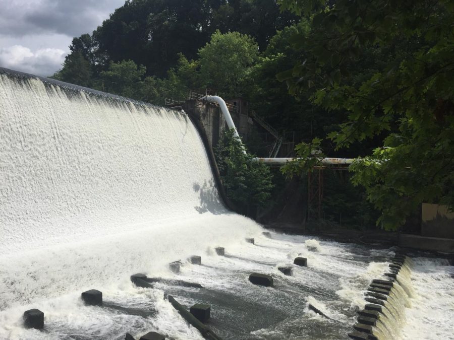
Gorge Metro Park
Distance from Kent: 21 minutes
Trailhead:1160 Front St. Cuyahoga Falls, Ohio 44221
Difficulty: Easy
Type of trails: Unpaved
There are two features of this park hikers need to see: The Gorge Dam and the Mary Campbell Cave. The Gorge Trail features the dam, labeled as the “Falls”, which gives an incredible view of the water surging back into the Cuyahoga River, while the other part of the trail leads to the cave. The cave is actually rock formations hanging over the trail, providing shelter. Near the cave are plaques that tell the story of the Mary Campbell Cave.
The Glen Trail features views of the Cuyahoga River and tall rock formations. In the winter, it makes the scene look like a “winter wonderland” with large icicles hanging off the rock walls. The icicles also pose no danger to hikers since the walls are a few feet from the trail.
Towner’s Woods
Distance from Kent: 8 minutes
2264 Ravenna Rd. Kent, OH 44240
Difficulty: Easy
Type of trails: Unpaved
This park has trails grazing the edge of a lake, with serene spots along the path to take in the view. Each path has easy terrain, with only a few challenges such as tree roots and rocks. This is the place for those looking for an easy-going hike, or a place to relax.
Portage Hike & Bike Trail
Located in downtown Kent, Ohio along the Cuyahoga River
Difficulty: Easy
Type of trail: Paved
For those looking for a fun walk with friends, this trail is located in the heart of Downtown Kent near the railroad tracks. The Portage Hike & Bike Trail scales alongside the Cuyahoga River with fun historic markings along the way. If walkers take the right side of the trail which heads toward Sheetz, they’ll find the history of Captain Brady’s Leap, the story of Standing Rock and the Beckwith Orchard Cider Mill a few miles down at the end of the trail.
Lydia Taylor is the editor-in-chief. Contact her at [email protected].