Megastorm could wreak havoc across 800 miles of US
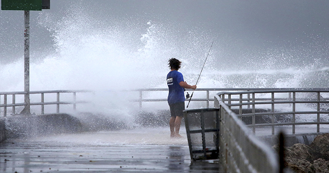
Eric Peterson, of Tequesta, casts his line and shoots some video of the waves on the fishing jetty at the Jupiter Inlet, Friday, October 26, 2012. (Lannis Waters/Palm Beach Post/MCT)
October 28, 2012
Allen G. Breed, Associated Press
Wayne Parry, Associated Press
SHIP BOTTOM, N.J. (AP) — Forget distinctions like tropical storm or hurricane. Don’t get fixated on a particular track. Wherever it hits, the behemoth storm plodding up the East Coast will afflict a third of the country with sheets of rain, high winds and heavy snow, say officials who warned millions in coastal areas to get out of the way.
“We’re looking at impact of greater than 50 to 60 million people,” said Louis Uccellini, head of environmental prediction for the National Oceanic and Atmospheric Administration.
As Hurricane Sandy trekked north from the Caribbean — where it left nearly five dozen dead — to meet two other powerful winter storms, experts said it didn’t matter how strong the storm was when it hit land: The rare hybrid storm that follows will cause havoc over 800 miles from the East Coast to the Great Lakes.
Governors from North Carolina, where steady rains were whipped by gusting winds Saturday night, to Connecticut declared states of emergency. Delaware ordered mandatory evacuations for coastal communities by 8 p.m. Sunday.
Sandy weakened briefly to a tropical storm Saturday but was soon back up to Category 1 strength, packing 75 mph winds. It was about 260 miles (420 kilometers) south-southeast of Cape Hatteras, N.C., and moving northeast at 13 mph as of 5 a.m. Sunday, according to the National Hurricane Center in Miami.
The storm was expected to continue moving parallel to the Southeast coast most of the day and approach the coast of the mid-Atlantic states by Monday night, before reaching southern New England later in the week.
It was so big, however, and the convergence of the three storms so rare, that “we just can’t pinpoint who is going to get the worst of it,” said Rick Knabb, director of the National Hurricane Center in Miami.
Officials are particularly worried about the possibility of subway flooding in New York City, said Uccellini, of NOAA.
New York Gov. Andrew Cuomo told the Metropolitan Transportation Authority to prepare to shut the city’s subways, buses and suburban trains. The city closed the subways before Hurricane Irene last year, and a Columbia University study predicted that an Irene surge just 1 foot higher would have paralyzed lower Manhattan.
Up and down the Eastern Seaboard and far inland, officials urged residents and businesses to prepare in ways big and small.
On Saturday evening, Amtrak began canceling train service to parts of the East Coast, including between Washington, D.C., and New York. Airlines started moving planes out of airports to avoid damage and adding Sunday flights out of New York and Washington in preparation for flight cancellations on Monday.
The Virginia National Guard was authorized to call up to 500 troops to active duty for debris removal and road-clearing, while homeowners stacked sandbags at their front doors in coastal towns.
“You never want to be too naive, but ultimately, it’s not in our hands anyway,” said Andrew Ferencsik, 31, as he purchased plywood and 2-by-4 lumber from a Home Depot in Lewes, Del.
Utility officials warned rains could saturate the ground, causing trees to topple into power lines, and told residents to prepare for several days at home without power.
President Barack Obama was monitoring the storm and working with state and locals governments to make sure they get the resources needed to prepare, administration officials said.
In North Carolina’s Outer Banks, a group of about 20 people was forced to wait out the storm on Portsmouth Island, a former fishing village that is now uninhabited and accessible only by private ferry.
“We tried to get off the island and the ferry service shut down on us,” said Bill Rowley, 49, of Rocky Mount, N.C.
Rowley said he could see 15-foot seas breaking over the island’s dunes, enough to bring water to the island’s interior.
“We’ll be inundated and it’ll probably be worse tomorrow,” he said.
The storm also forced the presidential campaign to juggle schedules. Romney scrapped plans to campaign Sunday in Virginia and switched his schedule for the day to Ohio. First lady Michelle Obama canceled an appearance in New Hampshire for Tuesday, and Obama moved a planned Monday departure for Florida to Sunday night to beat the storm. He also canceled appearances in Northern Virginia on Monday and Colorado on Tuesday.
5 reasons why Sandy is expected to be a superstorm
1. A NORTHBOUND HURRICANE
Hurricane Sandy is moving slowly toward the north-northeast but is expected to turn to the north and west later Sunday and Monday, forecasters say. At some point, it’s expected to become what’s known as an extratropical storm. Unlike a tropical system like a hurricane, which gets its power from warm ocean waters, extratropical systems are driven by temperature contrasts in the atmosphere.
Although Sandy is currently a hurricane, it’s important not to focus too much on its official category or its precise path (current models show it making landfall over New Jersey or Delaware sometime early Tuesday). It’s a massive system that will affect a huge swath of the eastern U.S., regardless of exactly where it hits or its precise wind speed. For example, tropical storm-force winds can be felt more than 500 miles from the storm’s center, according to the National Hurricane Center. It’s already caused some minor flooding in North Carolina’s Outer Banks and has prompted evacuations elsewhere. The Federal Emergency Management Agency has personnel and supplies spread as far west as the Ohio River Valley, said Craig Fugate, the agency’s director.
2. EARLY WINTER STORM
Sandy is expected to merge with a wintry system from the west, at which point it will become the powerful superstorm that has forecasters and officials across the eastern U.S. Winds from that system will pull Sandy back toward the U.S. mainland.
3. ARCTIC AIR FROM THE NORTH
Frigid air coming south from Canada also is expected to collide with Sandy and the wintry storm from the west, creating a megastorm that is expected to park over the northeast for days. The brunt of the storm could hit areas farther inland. Officials are bracing for the worst: nearly a foot of rain, high winds and up to 2 feet of snow.
4. HIGH TIDES COULD WORSEN FLOODING
Further complicating matters is the possibility for dangerous storm surges: A full moon means the tides will be higher than usual, which will make it easier for the storm’s powerful winds to push water into low-lying areas. That, coupled with the threat of several inches of rain, has officials working to shore up flood defenses.
Storm surge could reach anywhere from 2 to 11 feet along the northeastern coast, forecasters say. Inland river flooding also is a serious concern.
5. COMBO OF SNOW, WIND INCREASES RISK FOR WIDESPREAD POWER OUTAGES
Storms in recent years have left hundreds of thousands of people in the eastern U.S. without power, sometimes for days at a time. Utilities have been bringing in extra crews and lining up tree trimmers so they’re prepared, and with good reason. The superstorm brings two possibilities for knocking out electricity. For one, hurricane-force winds of at 74 mph could send tree branches into power lines, or even topple entire trees and power poles. Those left standing could succumb to snow, which could weigh down still-leafy branches enough to also topple trees.