Kent updates campus with redesigned maps
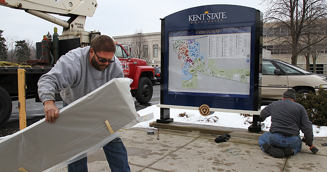
Workers replace a campus map between Franklin and Rockwell halls. The new maps feature LED lighting. Photo by Rachel Kilroy.
February 22, 2012
Look out for the new campus maps that are currently being refurbished around campus. The office of the University Architect is replacing the large, campus map signs – also known as vehicular signs – with a fresh, up-to-date version of Kent’s campus.
The seven replacement maps cost approximately $25,000, said Michael Bruder, director of designing construction of University Architect. The main difference is the LED back lighting that will replace the fluorescent tubes in the current maps.
Brian Pickering, project manager of University Architect, said the new maps were designed to reflect the maps that are currently on the pedestrian wayfinding signs – the tall blue signs with pictures of the academic buildings.
Aimee Crane, visual communication design grad student, designed the pedestrian wayfinding signs and the map on them about three years ago.
“It started off as a class project,” Crane said. “My professor at the time had worked with students in the past about the different districts of our campus and conducted surveys trying to understand the campus. My class then took that research, designed a map and mine happened to be the one the university chose to use.”
The map on the pedestrian signs is color coded into five districts: Front Campus, Music and Theatre, Residential, Science Mall and Recreation. Crane said she wanted to break up the campus into identifiable sections that people could recognize.
These five districts are what the new, vehicular signs are based on.
“The point of doing this was to update the map and to reflect more of what the campus looks like today and also implement the new districting,” Pickering said.
So far there are three maps finished, located by Franklin Hall, Music and Theatre building and Lake and Olson halls. There are four more that still need to be reconstructed and will be located in front of the Ice Arena, behind the Student Center, in front of the M.A.C. Center and on Janik Drive.
Pickering said all the maps will be finished by May 1.
Contact Dianna Warwick at [email protected].