New technology gives birth to old ideas
June 25, 2008
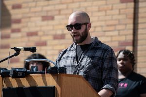
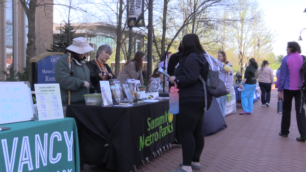
Yukihiro Suzuoki, geographical information systems graduate student, instructs a small class of six students with whom he regularly teaches on a one-on-one basis. David Ranucci | Summer Kent Stater
Credit: DKS Editors
Kent State students are discovering what administrative secretary Mary Lou Church calls “a neat way to do research.”
Geographic information system, sometimes referred to as geographic information science, is a program that allows students to use computers to analyze and display geographic spatial information.
“The idea has been there for a while,” Church said, “but the technology is new.”
Jay Lee, chairman of the geography department, said the program is “the backbone of a very prosperous (field), geospatial technology.”
Yuki Suzuoki, a Kent State graduate student from Japan, is teaching a GIS class this summer. He calls it “a really fun class to learn and teach.”
“What we can do is visualize what we cannot see usually,” Suzuoki said. “GIS enables us to find solutions to a lot of real-world problems we are facing today.”
Suzuoki explained that GIS is used for land use planning, environmental management, sociological analysis, business marketing and more.
“GIS is not only creating maps,” he said, “but also analyzing spatial relationships in various fields to find out better solutions (for) the future.”
GIS is a specialty to the geography department but is branching out into various other fields as well.
“We have students from geology, environmental conservation and geography majors,” Suzuoki said, adding that in the past, archaeology and sociology students have also been interested in the courses.
GIS classes use a software program called ArcGIS, which came from the Environmental Systems Research Institute. Suzuoki uses the software in his introductory class, but he explained that Kent State offers advanced classes as well.
“We have advanced GIS, spatial programming, Internet GIS, statistical methods using GIS and some other cartography courses,” he said.
According to Lee, job placement in the GIS program is incredibly high – the third-highest in the country.
“We have been receiving a lot of success for placing our graduates,” Lee explained. “We also provide opportunities for students to intern with agencies in and around the community.”
A lot of times, students are able to turn their internships into full-time jobs, he added.
“Once they see the benefit of using GIS and the GIS proficiency our students have,” he said, “they often want to retain that in their work environment.”
The program, which began with five to 10 students signing up for one class a year, has grown to three courses being offered every year, with waiting lists of students wishing to take them, Lee said.
However, the prospect of losing one of its professors will determine how many classes continue to be offered, he added.
“If the position doesn’t come back,” he said, “I will have to cancel a lot of classes, and that will be a disservice to our students.”
Contact principal reporter Maria Nann at [email protected].